
All About Death Valley National Park
Covering 3.4 million acres – 91% of which is designated Wilderness, California’s Death Valley National Park is the largest National Park in the Contiguous United States. It is also the lowest, hottest and driest place in North America. Awe-inspiring vistas, intriguing geologic features and a rich – sometimes whimsical – cultural history make Death Valley one of the country’s most unique National Parks. With so much ground to cover, it can be a daunting task deciding where to start – so let’s take a look at some of the most unique attributes and top must-see sites of this desert playground.
Quick Facts:
- Size: 3.4 Million Acres
- Wilderness: 91% of the Park
- Human History: circa 10,000 years
- Visitors: 1 million per year
- Designated a National Park: October 31, 1994
Geology
With an abundance of amazing hikes, surreal sites and wondrous vistas, any visit to Death Valley National Park necessarily includes an appreciation for its unique geology.
To further this appreciation, be sure to visit the
Top Geologic Wonders of Death Valley:
- Eureka Sand Dunes
- The Racetrack
- Badwater Basin
- Ubehebe Crater
Before we explore what makes them must-see sites, let’s first build a picture of the landscape and how it formed.
Legends of the Land
The Timbisha Shoshone, who have occupied the area for at least 1000 years, have a legend of the “Queen of Death Valley”. It tells the tale of a beautiful queen, lustful for power, ruling at a time when the Valley was lush with a large lake and an abundance of vegetation. In her vanity, she ordered that a mansion be built. It was to be a monument to outdo any built by her southern neighbors, the Aztecs. In this endeavor she came to enslave her own people.
Growing in her obsession, and vexed by its slow progress, she became a harsh ruler. At the height of her frustration, she flogged her own daughter for moving too slowly. Turning to her mother, the girl cursed the Queen and her kingdom before succumbing to the heat and dying of exhaustion.
To punish the queen, nature itself rose against her – drying up the lakes, wilting the vegetation and transforming the landscape into a barren, dry land.
While we can never know if this oral tradition holds true, nor have evidence that such a figure ever existed, it does represent the geological history of what we now call Death Valley National Park.
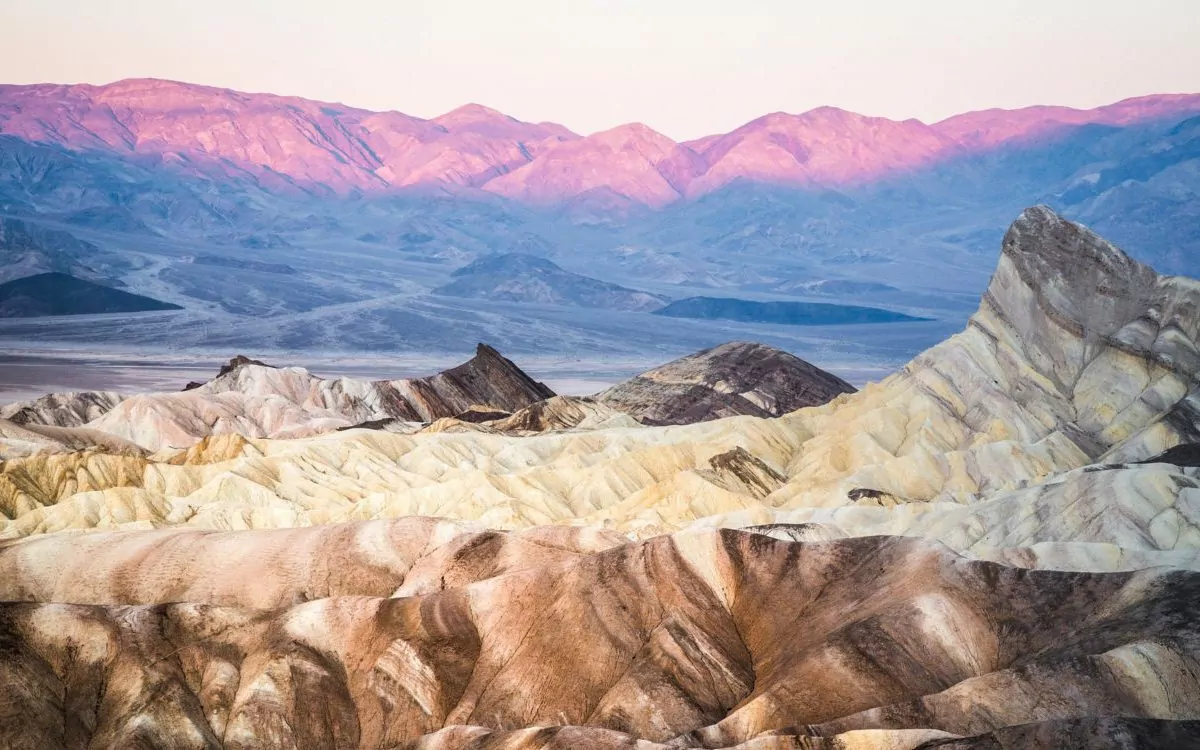
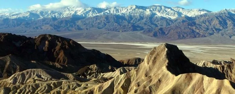
How Death Valley Formed
Death Valley National Park contains some of the oldest exposed rocks on earth. The most ancient of these formed more than 1.2 billion years ago. Composed of limestone, these rocks give us an idea of what the land looked like. Limestone is formed by the shells and bones of sea creatures. They sink to the bottom and compress into rock over time. This tells us that 1.2 billion years ago, the land we know as Death Valley was actually a shallow sea. The discovery of fossils provides further evidence. Stromatolites (cabbage-like creatures that were ancient algae) are some of the earliest forms of life on the planet and they have left their imprints on the rocks – preserved by the now arid environment.
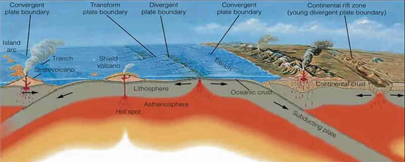
Around 100 million years ago the earth’s crust started shifting and the oceanic plate began sinking under the North American plate. This caused the ground to rise and the friction forced hot magma up through the earth’s crust creating volcanoes and chasing away the shallow sea. We see dramatic evidence of this volcanic history at Ubehebe Crater.
As faulting and tectonic shifting continued, the mountains rose and the valley began to sink. This process continues today. The valley, still sinking, is continually filled in by sediment washing down from the surrounding mountains.
10,000 years ago the glaciers which had covered much of North America began to melt and recede. They left behind a large freshwater lake, known as Lake Manly. At its height, Lake Manly was 80 miles long and 800 feet deep! As the climate continued to warm, Lake Manly evaporated, leaving behind the valley floor and salt flats we see today (and lending some credibility to the Queen of Death Valley legend).
The result of this long and complicated process is the spectacular scenery that now makes up Death Valley National Park.
Eureka Sand Dunes
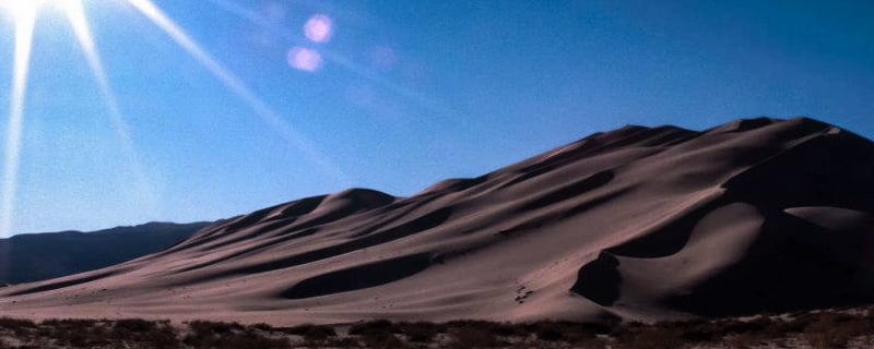
Accessed from the North entrance to the park (or the adventurous and sometimes technical 4×4 route from Saline Valley through Steel Pass), the Eureka Sand Dunes are the tallest dunes in California – potentially the tallest in North America. They rise 600 feet from the floor of the valley.
Though the Mesquite dunes cover a larger area, there is a special draw to the Eureka Dunes. Perhaps it’s their remoteness – the north end of the park is a little more isolated and much less visited. Perhaps it’s one of their most unique features that lends an air of the ethereal to these particular dunes: they sing.
As sand avalanches from the steepest dune or the highest peak the dunes emit a droning hum, the sound comparable to a pipe organ or passing plane. The phenomenon is not completely understood, though it’s believed that it may be related to the texture of the sand grains and the friction of them sliding against one another.
Resting in the shadow of the Last Chance Mountains towering 4,000 feet above them, the Eureka Dunes represent a striking landscape. Camping is allowed in the area, though not on the dunes or at their base where a delicate eco-system of flora and fauna exist. To further protect this fragile system, off-road driving is prohibited in the area. Though, as we will see, there are plenty of technical 4×4 opportunites while remaining ON road in the remote reaches of the park.
The Racetrack
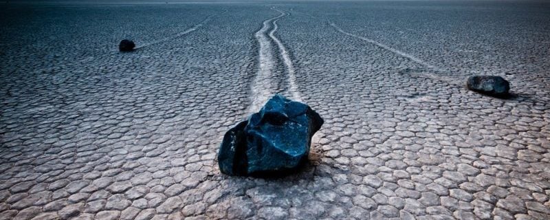
One of Death Valley National Park’s most remarkable geologic features is also its most enduring mystery. The Racetrack Playa sits at an elevation of 3700′. The Last Chance and Cottonwood Ranges surround it. It is a rugged and remote landscape with an incomparable night sky. Approximately 10,000 years ago the lake which covered the area evaporated, leaving behind the beige-colored mud floor – about 1,000′ thick.
What makes the Racetrack truly unique, however, has sparked debate among researchers for many years: rocks that move on their own!
The mysteriously moving rocks, some weighing up to 700 pounds, leave long trails in the dry lake bed as evidence of their travels. For decades researchers have pondered and debated just how such a curiosity could occur. In 2014 a research project headed by a team from the Scripps Institution made a lucky discovery when they witnessed the rocks move! Their observations suggest a series of events which need to occur to allow the rocks to move across the desert floor “by themselves”.
When the mud floor becomes covered by rainwater a few inches thick, and night temperatures plummet to the right degree, sheets of ice form and begin to shift about the Playa, pushing the rocks before them as they go.
Though this may not completely close the book on the long standing debate, it is the most conclusive data to date.
Camping is allowed at the Racetrack, though the road to get there can be a challenge and High-Clearance 4×4 vehicles are recommended.
Badwater Basin
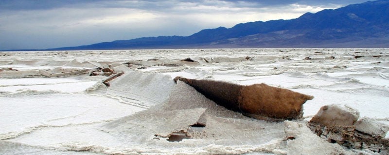
At 282 feet below sea level, Badwater Basin is the lowest point in North America. That endowment alone, however, doesn’t describe the photographer’s dream that is Badwater. Uplifting salt crystals form striking polygonal structures that stretch into the mountain-studded horizon – which, at sunset, is aflame in pink and magenta.
Sediment deposited from the surrounding mountains over the millennia fills the valley floor. This debris is over 3 miles deep before the bedrock. Due to the stretching forces that created this basin, the Earth’s continental crust is at it’s thinnest here. It’s about 16 miles thick – the average is 25 miles and under big mountain ranges like the Sierra Nevada and the Himalaya it can be as much as 50 miles thick!
A 1/4 mile hike from the parking lot immerses you in this otherworldly landscape, making this a must-see if you only have a few hours to spend in the park.
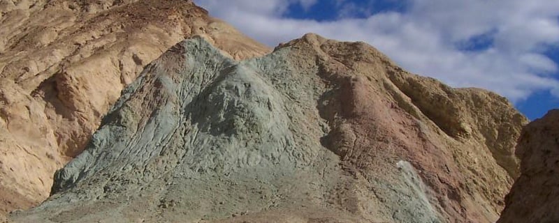
From the Furnace Creek Visitor’s Center, it’s about a 30 minute drive to the Badwater parking area. Heading south on Highway 190, turn onto Badwater Road. On the way back, make a short detour along Artist’s Drive to see the pastel-colored formations of Artist’s Palette.
Ubehebe Crater
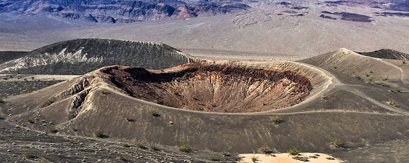
One of the most dramatic examples of Death Valley’s sometimes violent geologic history is Ubehebe Crater.
Ubehebe, a Paiute name pronounced YOO-bee-HEE-bee, is 600 feet deep and about a 1/2 mile wide. When hot magma rising up to form a volcano hit groundwater, the water instantly vaporized. The rapidly expanding steam exploded outwards, creating the hole we now see. It is estimated that this took place about 2100 years ago, though some point to evidence that suggests it is much younger. Some of these volcanoes may have erupted as recently as 800 years ago!
The Timbisha Shoshone know this astonishing feature as “Tem-pin-tta- Wo’sah” which translates to “Coyote’s Basket”.
There is ample opportunity to hike around and into this geologic wonder. Hiking the rim will reveal various other craters, including Little Hebe. Hiking down into the crater is a fascinating experience, but remember: what goes down must come up! Bring plenty of water and allow some extra time for your ascent back to the rim.
Ubehebe is about 90 minutes one-way from Furnace Creek, though if you are planning to check out The Racetrack, the crater is around the halfway mark.
Hike Death Valley National Park with a Guide
Guided Death Valley hiking and backpacking trips are available, and are a stress-free, exciting way to do this trip. The tour company handles permits, gear, transportation, meals, and provides a professional guide so you can focus 100% on enjoying your adventure. Read more…
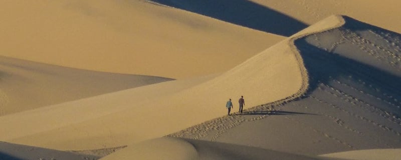
Hiking Death Valley
With 91% of the park being officially designated as wilderness, there are boundless opportunities to strap on your boots and strike out across the landscape. Death Valley hikes can be challenging and incredibly rewarding. From short jaunts to Valley-to-Summit expeditions, you are bound to find a route that is best suited to you.
A WORD OF CAUTION however! Death Valley is a rugged, austere and potentially deadly environment. Before setting out on any hike, it is always a good idea to check in with the ranger station. Let them know the route you are taking and how long you intend to be out. They can give you invaluable information about the route and what conditions you might expect. Be certain that you have enough water (i.e. don’t rely on an old map that says there should be a spring at point x). Being ill-prepared and having a lack of respect for the desert environment can be (and has been) fatal. This is not at all meant to scare you from experiencing the backcountry wonders of Death Valley, but instead to ensure that you have the safest and most enjoyable trip possible. Education is key.
Alternatively, consider taking the trip with a medically-trained guide with desert-specific knowledge who will handle these logistics for you.
Once fully-informed and equipped, any of the following hikes will be sure to challenge you and leave you with an incomparable sense of accomplishment and awe.
Death Valley’s Must-Do Hikes:
- Telescope Peak
- Cottonwood Canyon to Marble Canyon
- Wildrose Peak
- Desolation Canyon
- Mesquite Flat Sand Dunes
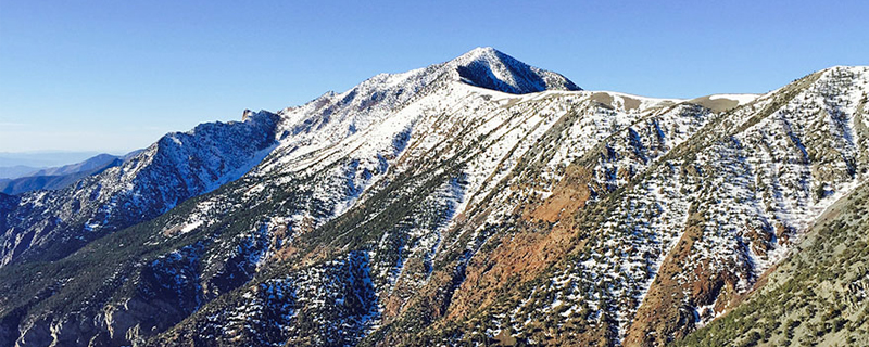
Telescope Peak
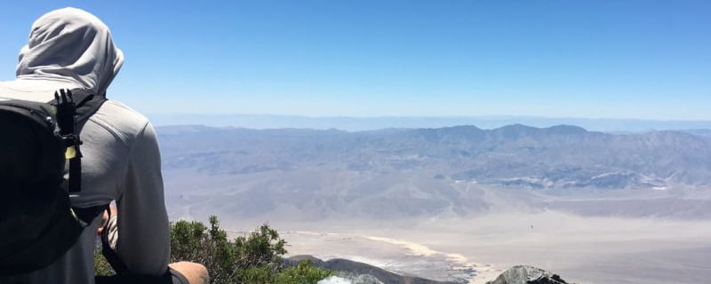
This Below-Sea-Level-to-Summit epic that takes you from trailhead to top in just under 20 miles is the ultimate Death Valley achievement. Taking the Shorty’s Well Route, this trek begins in Badwater Basin, 250 feet below Sea Level. Hiking through Piñon Pine and Mountain Mahogany forest to emerge above the vegetation line and look down upon Death Valley more than 8000 feet below, expect your lungs to burn, your muscles to ache and your body and being to take note of the drastic elevation change. Remember: water is your friend!
Following the road that “Shorty” Borden (a 65-year-old Death Valley prospector) hand dug in the 1920s, you’ll witness the remnants of Death Valley’s recent human history: the mining boom days. Passing the skeletal remains of mine works – wooden frameworks standing like ghosts of the past against the stark wilderness – its hard not imagine the days when men clamored up these hills in search of riches.
Nearing the top, you’ll pass by Bristlecone Pines – known to live up to 5000 years and among the oldest living entities on earth!
This hike offers just about all Death Valley has to give. Traversing through various climatic regions, camping in remote wilderness and reveling in the accomplishment of summiting a 2-mile high peak should put Telescope Peak at the top of your Death Valley hiking list.
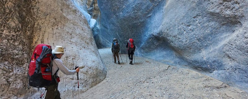
Cottonwood Canyon to Marble Canyon
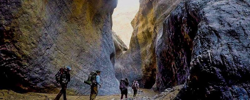
This 26-mile loop takes you through slot canyons, over dryfalls and into the heart of desert hiking. Seasonal springs and desert oases provide water along the route and make for natural stopping points.
This hike is a great opportunity to witness the power of water and flash floods that have carved and polished these canyons over time and contributed to forming the Death Valley landscape.
As you hike, take care to notice petroglyphs – ancient rock art – on the canyon walls, evidence of prehistoric human occupation.
Camp near oases and sleep under the most brilliant night skies you might hope to see.
Wildrose Peak
Peakbaggers take note: Death Valley has plenty of challenging summits to tackle!
The second summit route in our must-do list is Wildrose Peak. Like the Telescope Peak hike, Wildrose offers a window into Death Valley’s mining history. The hike begins at the historic Wildrose Charcoal Kilns. These “coke” kilns were used to create fuel for the smelting process.
Gaining an elevation of 2200 feet, the hike – and resulting views – will likely leave you breathless. Looking across the horizon upon Death Valley, Panamint Valley and the Sierra Nevada range to the West, you’ll have a deeper appreciation for the physical challenge that led you to this spectacular vista.
8.5 miles roundtrip, this hike is a challenging but doable day hike. Returning to the valley, you can refuel as you look up to the day’s literal high-point.
Desolation Canyon
This is a moderate hike that is 3.6 miles out and back. You can add to this mileage by exploring several of the side canyons and drainages that branch off from the main trail. If you lose track of where you are, a good tip to keep in mind is that downhill is generally the way back (i.e. the path of water).
There are a couple of 6-8 foot dry falls you will need to scramble up. Though not technical, you’ll want to take care on your way back out as it’s always more difficult climbing down.
As you hike into the Black Mountains and the canyon begins to close around you, you’ll notice its colored walls rising above you. Purples, greens and blues, reds…all are the result of various minerals in the rock coming to the surface. Mostly iron-based substances, they include Hematite (red, purple), Limonite (yellow), and Chlorite (green/blue).
Depending on the time of year, desert canyons can become ovens in the midday sun, so be sure to check the weather before you head out and if necessary, hike early in the morning or late in the afternoon.
The trailhead is less than 4 miles south of Hwy 190 off of Badwater Road, making this an ideal hike to pair with a visit to Badwater Basin.
Mesquite Flat Sand Dunes
The trek to the tallest dune and back is a 2-mile roundtrip hike. If you are short on time this is a great way to get out and do a bit of cross-country travel. Even with short mileage you’ll be hiking through sand, so you’ll still manage to get a calf and quad workout. If time is on your side, there is much to explore in this 14-sqaure-mile dune field, and you can make the hike as long and arduous as your imagination and stamina will allow!
Dwarfed by the Eureka Dunes, the tallest peak is only 100 feet high, but the area they cover is vast.
Sand dunes form when sand from eroding canyons and washes gets swept down into the valley. Over time wind blows the sand across the desert floor until it finds a spot to begin accumulating. Once this process begins, the dune building action repeats itself and mountains of sand begin to grow.
The most accessible sand dunes in the park, the Mesquite Flat Sand Dunes are located in Stovepipe Wells and are easily reached from Hwy 190.
Hike Death Valley National Park with a Guide
Guided Death Valley National Park backpacking and hiking trips are available, and are a stress-free, exciting way to do this trip. The tour company handles permits, gear, transportation, meals, and provides a professional guide so you can focus 100% on enjoying your adventure. Read more…
Death Valley’s Human History
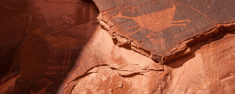
Death Valley’s human history is as rich and colorful as the rock formations that paint it’s horizon. Archeological evidence points to the Ancient Ones occupying the area at least 10,000 years ago. We can see some of this evidence carved into the rocks at various locations throughout the park.
Rock art – petroglyphs and pictographs – litter the canyon walls and give a small window into the past. The petroglyphs can be dated thanks to the aging process of exposed rock in the desert. As a person carves into the rock, they expose fresh layers of rock to the air. Over time what is known as desert varnish forms. Desert varnish is a blackish material that forms on the rock surface. It is composed mostly of manganese which oxidizes with the air. Measuring the thickness of desert varnish growth gives us an idea of when the art was carved into the rock.
These are the records of our past and any visit to Death Valley should include an appreciation of and respect for the ancestors who came before us. Be careful to preserve these priceless artifacts and refrain from defacing the art or the rocks themselves, so that generations to come might share this connection to the ancient past.
Timbisha Shoshone
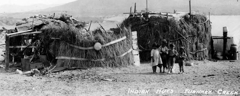
The Timbisha Shoshone People have lived in the Death Valley region for over 1000 years. The name “Timbisha” means red rock face paint – a reference to the rouge they would adorn themselves with in ceremonies. It represented where the tribe got its strength: from the Earth.
They were formerly known as the Panamint Shoshone Indians of Death Valley. The Panamint Shoshone were reknown for their basket making skills – baskets weaved so finely they could be used to hold and boil water.
Adept at finding springs and subsistence from the desert, the Shoshone survived on the land for centuries.
The tribe did not receive Federal Recognition until 1983. They were not ceded any of their ancestral lands at this time, however. In 2001 the tribe succeeded in having some of their lands returned. The Timbisha Homeland Act of 2001 allotted 7000 acres to be held in trust for the tribe. The reservation is near the Furnace Creek area, and the tribal council maintains a headquarters in nearby Bishop, CA.
Harmony Borax Works
Death Valley National Park has more than 18,000 mining features dotting its landscape. The area has seen innumerable prospectors who came to pry their fortunes from her hillsides. The boom days began with the 49ers who rushed for the Gold Fields of the Sierra Nevada. In fact, the name “Death Valley” was given to the region by a group known as “The Lost 49ers“.
Convinced they’d find a shorter route across the Sierras and to California’s gold fields, they separated from the wagon train they were with. Striking westward across the desert, they landed in Death Valley. After many calamitous events, the group was rescued and led out of the valley. A member of the party looked back and uttered “Goodbye, Death Valley”.
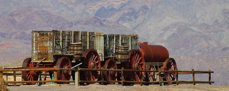
While many came in search of gold, there was another mineral that Death Valley had in abundance: Borax. Known as the “White Gold of the Desert”, borax was used as an antiseptic and detergent. The Harmony Borax works, built in 1883, employed 40 men at its height. It produced about 3 tons of crystalline borax per day.
Mule teams hauled wagon loads out to market. Stephen Mather (godfather of the National Parks Service) used the image of the “20-mule Team Wagons” to idealize Death Valley and the product itself. The 20-mule Team Wagon image has become iconic of the National Park.
Rhyolite Ghost Town
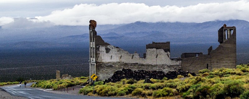
The remains of the boom and bust mining days dot Death Valley’s landscape. Ghost towns stand as monuments to what were once bustling, rough and tumble mining towns.
Rhyolite is sometimes referred to as the most photographed ghost town in the west. It lies just outside the Park boundaries in Nevada. There are a number of buildings in various states of decay which make for striking photography. In 1904, prospectors found rich veins of gold in the region. They made over 2000 claims in a 30-mile area. For a short time Rhyolite flourished. Make-shift mining towns were generally built out of wooden structures or canvas walled tents. Rhyolite’s stone buildings speak to the faith its inhabitants had in its permanence and the area’s never-ending riches.
Rhyolite is only a few miles from the town of Beatty, NV where you’ll find the Beatty Museum and Historical Society. Be sure to check out the Goldwell Open Air Museum next to Rhyolite and its quirky desert-art installations.
Modern Desert Dwellers:
People living in the desert today are a hearty and unique group. Death Valley has many small towns surviving today such as Darwin, just outside the park boundary. Local residents offer tours of the town and a bit of its history.
Desert folk tend to have their own unique culture and appreciation for the landscape. Some have descended from the earliest pioneers to the area. It is common to see various forms of artwork at random locales throughout the desert and the people tend to feel a kinship to those that share their love of this rugged environment.
Saline Valley
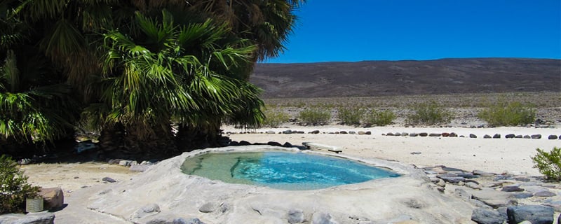
Saline Valley represents a spot people have gathered through the generations. Brought here as children by their parents, many people now bring children of their own. Infrequently visited by the masses, it is in the remote north end of the park. Those who make the trip time and again, though, have a deep love for the place.
Every thanksgiving the “regulars” host a potluck dinner at the Saline Valley Warm Springs. It is not uncommon to see people deep-frying turkeys over campfires (NOT recommended!). Folks bring various homemade dishes to the springs to share with their fellow revelers. The springs themselves represent the most picturesque scene you could hope to immerse yourself in. Sitting in 96-98 degree water in a fashioned pool a few feet from the mineral spring, you have palm trees behind you, a salt desert floor stretching before you, snow-capped mountains surrounding you and a milky-way-studded sky above you. A true desert Oasis.
Use Caution! The road to Saline Valley Warm Springs can be treacherous depending on the winter snowfall and various other elements. There is a north and a south pass into the valley. It is best to check with Park Rangers to see which route is (the most) passable. Don’t be fooled by your maps app that tells you it’s only 50 miles from the highway. Often times you will be unable to travel faster than 10-15 miles per hour. As a result, 50 miles becomes an all day endeavor. Prep yourself and your high-clearance vehicle. The reward is one of the desert’s true gems.
Hike Death Valley National Park with a Guide
Guided Death Valley National Park backpacking trips are available, and are a stress-free, exciting way to do this trip. The tour company handles permits, gear, transportation, meals, and provides a professional guide so you can focus 100% on enjoying your adventure. Read more…
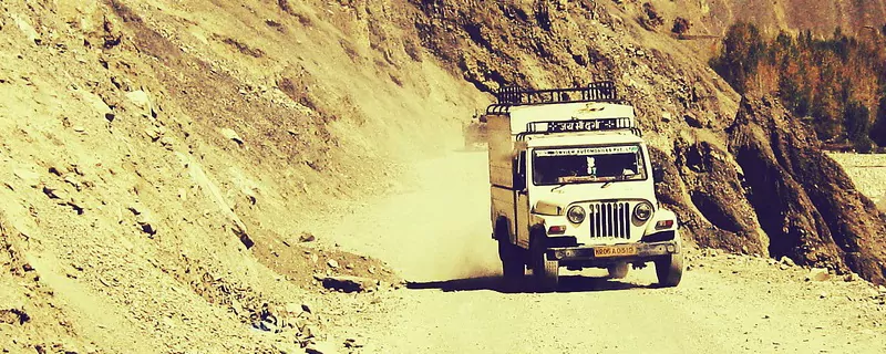
Death Valley 4-Wheel Drive Adventures
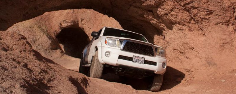
Off-road driving is prohibited in Death Valley, as it is in all protected National Parks. However, that does not mean you can’t find technical 4×4 adventures while staying ON road. Most of the backroads in Death Valley are old mining roads. They may or may not be regularly maintained. They can represent epic adventures or harrowing tales of survival. Many are a car-length wide, often with steep cliffs and various obstacles to overcome. Be sure to inform yourself about the current conditions of the route and be prepared with some basic 4×4 know-how.
Preparation can save your life! If a road becomes washed out, if you blow a tire (or two!), if any kind of mechanical calamity should befall you, you will be in trouble if you’ve only prepared to be out “for a few hours”. Plan to be out for a few days! You will have no cell service, no access to water, and you may not see another human being for days. Bring extra water and food. Pack enough clothing and gear (tent, sleeping bags, etc) to survive if you need to. Also, don’t rely on GPS. Get an updated map and know where you are on it.
Now on to the fun stuff!! Once prepped and ready to set out, check out some of the best 4-wheeling adventures the desert has to offer!
Epic Death Valley 4×4 Routes:
- Steel Pass
- Lippencott Mine Road
- Titus Canyon
Steel Pass
Steel Pass represents a badge of honor for many Death Valley enthusiasts. Accessed by Saline Warm Springs Rd, you pass through technical rock crawling dryfalls and vehicle-wide slot canyons. Whimsical sites like “Piston Point” (enshrined with pistons presumably blown out by the heat or stress of the route) make great photo-ops.
Saline Warms Springs Rd stretches north of the Springs and can seem like a run-of-the-mill dirt road. Don’t let this fool you. Once you reach Steel Pass you will not be able to turn around. Attempting it in anything but a High-Clearance, preferably 4-wheel drive vehicle is a recipe for disaster.
Make your way through the slot canyon, crawling over and down dryfalls. The walls will begin to recede and open up onto the Eureka Valley. You will be rewarded with a stunning and seldom seen view of the Eureka Sand Dunes.
Lippencott Mine Road
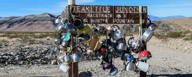
Lippencott Mine Road will make even the most seasoned off-roader’s pulse race. Sharp curves, steep grades, and intimidating drops-off make this route a daring 4×4 adventure. A sign that reads “Route Ahead Not Recommended for Vehicle Travel” marks the start of the road.
Depending on your preference you can choose to first-gear it downhill, or make the climb up. If up is your chosen direction, you start in Saline Valley. Travel about 34 miles from Hwy 190 on Saline Valley Rd. You’ll see a right-hand turn marked by a large rock cairn. Drive to the foot of the mountain and begin your low-gear ascent. If you’d rather go down, go north from Furnace Creek, past Tea Kettle Junction to The Racetrack. At the southwest corner of Racetrack Playa you will meet up with Lippencott and soon after begin your descent. Regardless of the direction, remember that the vehicle traveling uphill has the right of way. Keep your eyes peeled because the road is often only wide enough for one vehicle.
This is an adventurous, but arduous and technical route. Only experienced 4-wheelers should even attempt it. Be sure to bring survival supplies. You might not see another vehicle for a few days.
Titus Canyon
If Steel Pass and Lippencott Mine Road are above your current level of expertise, don’t be discouraged! Death Valley has an adventure for everyone.
Titus Canyon is the most accessible backroad route in our list. 27 miles long, it begins at Nevada Hwy 374, about 2 miles east of the park boundary. You’ll travel through canyon narrows, pass ghost towns and marvel at colorful rock formations. This is the busiest backcountry road in Death Valley, so be aware of your fellow travelers and practice good trail etiquette.
Titus Canyon Rd is generally passable in high-clearance 2-wheel drive vehicles. However, before you hop in your rented sedan and race out, check the current road conditions. Weather can be variable and have an impact on the road surface. Rain and washouts can make the route impassable. Be safe and know what to expect.
Death Valley National Park: Endless Epic Adventures
With 3.4 million acres, a person could spend a lifetime exploring Death Valley and still not see it all. This is NOT an exhaustive guide. This is simply a great place to start!
Hike Death Valley National Park with a Guide
Guided Death Valley National Park backpacking trips are available, and are a stress-free, exciting way to do this trip. The tour company handles permits, gear, transportation, meals, and provides a professional guide so you can focus 100% on enjoying your adventure. Read more…
Wildland Trekking Hiking Adventures
As the world’s premier hiking and trekking company, Wildland believes in connecting people to fantastic environments in amazing ways. Death Valley National Park offers an array of incredible hiking and trekking experiences. Wildland Trekking provides 6 different multi-day hiking and backpacking adventures in the Park. Read more about our Death Valley trips.
To learn more about our guided backpacking trips and all of our award-winning hiking vacations, please visit our website or connect with one of our Adventure Consultants: 800-715-HIKE

