


3 Epic Colorado Backpacking Trips
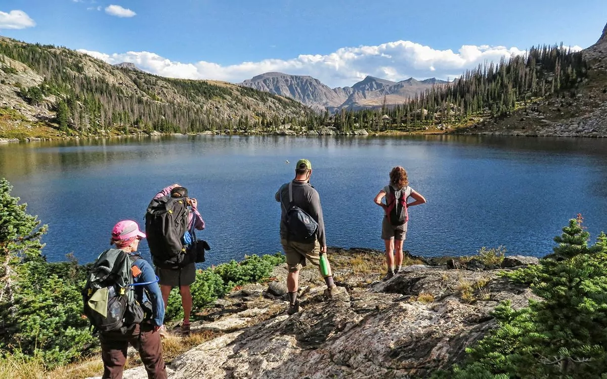
Colorado’s piece of the Rocky Mountains is arguably the most iconic chunk of America’s most famous mountain range — for good reason. Because of Colorado’s lower latitude (compared with Wyoming, Montana, and Idaho), treeline — the line at which trees stop growing — is at a pretty high elevation of approximately 11,000 feet. And luckily, Colorado boasts the greatest number of 14,000′ peaks and 13,000′ peaks in the United States. So, you’ll find an abundance of alpine terrain to backpack in and explore in this wonderful state.
Below treeline, the Colorado Rockies are heavily timbered with pine, spruce, fir, and aspen forests. After forest fires rip through conifers forests, aspen trees fill in the charred land. These groves are truly spectacular, often with lush green grass, sagebrush, and wildflowers carpeting the understory.
Near treeline, the only trees growing are spruce and fir, and they become stunted and gnarled by the intense weather at the higher elevations. The official name for these stunted trees is Krummholz, which is German for “crooked timber.”
Above the treeline, known as the “alpine zone,” there is nothing but grass, bushes, and wildflowers. This ecosystem is arguably the most thrilling to explore in the state of Colorado. In the alpine zone, you will find arctic tundra, fragile plants, stunning alpine lakes, possibly a glacier, and unique wildlife like Pika and Marmots.
Below are our favorite backpacking trips in Colorado. Enjoy!
Award Winning Colorado Backpacking Tours
| Trip | Difficulty | Days | Miles |
| Maroon Bells | Moderate | 4 | 28 |
| Mummy Range | Moderate | 5 | 25 |
| Flat Tops Backpack | Moderate | 5 | 24 |
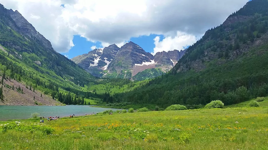
1. Maroon Bells Backpacking Trip
The Area
The Maroon Bells are Colorado’s most photographed cluster of mountain peaks because it looks as if created by computer imaging for a Hollywood blockbuster.
“The Bells” are part of the Elk Mountains, which straddle the border of Gunnison and Pitkin counties in west-central Colorado. They are the hallmark of the Maroon Bells-Snowmass Wilderness in the White River National Forest.
Most often captured from the shores of Maroon Lake, both peaks reach higher than 14,000 feet in elevation: Maroon Peak is 14,163 feet (4317 m) and North Maroon Peak is 14,019 feet (4273 m).
Geologically, the Maroon Bells differ significantly from much of the Rocky Mountain range, which is primarily composed of granite and limestone. In contrast, the Maroon Bells are composed of a unique type of mudstone that has solidified into solid rock over hundreds of thousands of millennia. This unstable rock breaks easily, leading to numerous climbing accidents over the years. However, this classic Maroon Bells backpacking route does not travel through dangerous mudstone terrain.
Trip Overview
The backpacking route highlighted here tackles four mountain passes and takes you by waterfalls, breathtaking views, wildflower-covered meadows and fantastic views of the Maroon Bells.
You’ll begin at Maroon Lake, which is easy to access and boasts incredible views of the Bells. Your trail leaves right from the lake and creates a loop back to the lake, so you don’t need to arrange any shuttles.
Getting There
The trailhead is at Maroon Lake, which is easy to find, but hard to reach. The road is open from mid June through September, but only before 8:00 a.m. and after 5:00 p.m. Between those hours, visitors are required to take a shuttle from Aspen Highlands Ski Area.
To reach Maroon Lake, first get to the popular ski town of Aspen, CO. Then, follow these instructions:
Driving Yourself from Aspen:
Either before 8 am or after 5 pm from the west side of Aspen, head southwest on Maroon Creek Road. Drive approximately 10 miles, past the Maroon Bells Welcome Center to Maroon Lake. There is a $10 fee for driving this road.
Shuttle:
Between 8 am and 5 pm, drive to Aspen Highlands Ski Area to catch the shuttle. You’ll need to pay a shuttle fee, which increases each year. If you are already in Aspen and do not have a vehicle, or the parking lot at Aspen Highlands is full, you can catch a free bus from Aspen to Aspen Highlands. Go to Ruby Park in Aspen and catch the Castle/Maroon bus to Aspen Highlands.
Recommended Day by Day Itinerary
Day 1:
For the best chance of avoiding the shuttle and getting a parking space, be at the trailhead around 6 am. From the trailhead, begin on the Maroon Lake Scenic Trail. After a short hike, you’ll come to the West Maroon Trail heading off to the left. Take this trail.
After a couple of miles, you’ll arrive at Crater Lake, a majestic mountain lake with amazing views. Take a break and soak up the views, then continue on the West Maroon Trail. After several more hours and a steep ascent, you’ll arrive at the first pass, West Maroon Pass (12,480 feet.) The views from up here are phenomenal! Take them in, then descend for another 1/2 mile and set up camp in the meadows below the pass.
Day 2:
Today you’ll start right up to the next mountain pass, Frigid Air Pass (12,415 feet). After the pass, continue on past multiple amazing waterfalls and several creek crossings. The trail climbs up again and then levels off near a small lake and creek.
Day 3:
Today you’ll climb the third pass, Trail Rider Pass (12,400 feet.) This one is not as difficult as the first two days of hiking, but the views are every bit as great! Descend from the pass to Snowmass Lake, which is a great spot for lunch. Continue on and set up camp near a pristine creek a couple of miles past the lake.
Day 4:
After a couple of miles, you’ll come to the final mountain pass, Buckskin (12,462 feet). Soak up the last high point views and then descend and continue 4-5 miles to the trailhead where your car is parked.
Permits
There are no permits required to do a backpacking trip in this area.
When to do this Trip
This trip is best done in July and August. June is feasible but the passes may have significant snow in places, and it can be muddy. September can be wonderful, with cold nights and possible snow toward the end of the month.
Campsites
The campsites for this trip are not designated. However, we strongly recommend camping in places that have been used before to reduce impact on well-vegetated areas.
Backpack Colorado with a Guide
Guided Colorado backpacking trips are available, and are a stress-free, exciting way to explore the amazing Colorado Rockies. The guide company handles permits, gear, transportation, meals, and provides a professional guide so you can focus 100% on enjoying your adventure. Read more about Colorado hiking guided trips…
All-inclusive Colorado Backpacking Adventures
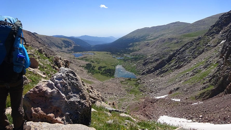
2. Mummy Range Backpacking Trip
The Area
This trip is in the wildest part of Rocky Mountain National Park – the Mummy Range along the northern boundary of the Park. This region is much more lightly visited than the very popular Bear Lake, Glacier Gorge, and Wild Basin sections of the Park. Given its solitude and native abundances, this region is a haven for the park’s large ungulates — namely, its thriving elk herds and the most prominent among them, the majestic (but not always subtle) moose.
Trip Overview
This is one of the more authentic and remote high-mountain Rocky Mountain backpacking environments one can experience in the lower 48. You’ll quickly forget you’re within the borders of a national park when you encounter the multiple peaks, craggy trails, and picture-book scenery brought to vibrant, heart-beating life with each mile you backpack.
While this trip starts in a mellow valley, it eventually ventures through scrubby tundra fields, traverses 11,000′ passes, breezy meadows, crusty, sun-cupped snowfields, and the shores of glassy alpine lakes. More than that, it tops out above 12,000′ on a day of off-trail navigation to tag multiple peaks. Camps will come with views hard to describe (even with the lens of a smartphone), thin air, and high-fives.
Getting There
From Denver:
Take Route 36 north toward Rocky Mountain National Park, going through Boulder, Lyons, and Estes Park. Stay on Route 34 west in Estes Park, until it splits south. Take Endovalley Road (closed in winter) then Old Fall River Rd. to the Chapin Pass trailhead.
Recommended Day by Day Itinerary
Day 1:
This relatively mild day is a warm-up for your legs and lungs, but your senses are put to the test. Chapin Creek’s watershed provides an incredible, verdant landscape to frame the massive and remote Mummy peaks that await you on day two. Expect to venture along the Cache La Poudre River, and look for campsites near Hague Creek. You’ll probably walk about six miles, and lose 500 feet or so of elevation.
Day 2:
While short, expect to get a workout as you venture deep into what makes this hike so picture-perfect. On the mainly forested trail, hikers will work their way up and down through heavy, green, and carpeted northern Colorado forest. As you reach treeline, search for a few of the available backcountry sites to establish camp for the night. If you’re feeling up to it, add another 6-mile round-trip jaunt to Mirror Lake. The total hike to camp is 2.5 miles, 1,000 feet up and down. You’ll be around 8.5 miles total if you add the side-hike.
Day 3:
Time to get after it. This is the big day and likely the one you’ll remember. Some hikers consider starting before first light. That may not be necessary, but you should get an early start to compensate for the elevation and afternoon storms that can be dangerous if you’re exposed above treeline. Bring your map and compass because you’ll need to navigate off-trail to reach Skull Point and Sugarloaf Mountain, both over 12,000 from sea level. However, the first few miles are on the trail and will take you over Mummy Pass. Camp shortly after the junction with Stormy Creeks Trail. This is a big day in terms of scenery, and you’ll work to earn it and the memories you’ll take back to the front country. This is about a 7-mile day with 1,250 feet of gain.
Day 4:
Hike on the now-downhill trail along the Thompson River toward Lost Falls. Consider a side-track up to Lost Lake, which is well worth your effort. Today’s hike may not include the big scenery of Day 3, but it’s pure Rocky Mountain outback, nonetheless. These backcountry days are exactly why you come to places like this. Find camp at one of the many established sites and set yourself up for a big, healthy dinner to prepare for your mild hike out on Day 5. Your day’s total hike is about 7 miles, all down hill for 1,000 feet.
Day 5: You’ll experience smooth sailing but plenty to see over the bow on the way down the Thompson River valley. Riparian environment, forest, and mountain views are hardly worth ignoring even knowing this is your last day. Celebrate all that’s left and all that you took in. Point your boots at the Dunraven Trailhead and, once there, take a load off, high-five your crew, and talk all about what you’ve accomplished. This is about a 5-mile day and a 1,500-foot loss.
Permits, Fees, and Reservation
Permits are required for backpacking trips in Rocky Mountain National Park. Permits are $30, you can find them on this website. In the busy season, permits can be reserved 60 days in advance, 30 days in advance from November 1 to April 30. You can pick them up at either the Beaver Meadows or Kawuneeche visitor centers.
When to do this Trip
Clearly, this is a trip best left for the mid-to-late summer and early fall, before the throes of winter once again embrace the park’s high elevation. The primary concern, especially for above-treeline off-trail travel, is afternoon lightning. Remember to be up, and back down, as early as possible during the hiking season. You can encounter snow year-round.
Campsites
The campsites on this trip are largely backcountry: some are established, others are primitive. It’s critical for all hikers to use sites already made unless there is a severe emergency requiring an overnight.
Night 1: Sites found the Cache La Poudre River’s junction with Hague Creek
Night 2: Established backcountry sites near Mummy Pass Creek trail junction with Mirror Lake Trail
Night 3: Sites found along Stormy Creeks Trail
Night 4: A number of designated backcountry campsites are found further east on Stormy Creeks Trail
Hike the Mummy Range with a Guide
Guided Mummy Range backpacking trips are available, and are a stress-free, exciting way to do this trip. The tour company handles permits, gear, transportation, meals, and provides a professional guide so you can focus 100% on enjoying your adventure. Read more…
All Inclusive Backpacking Trips
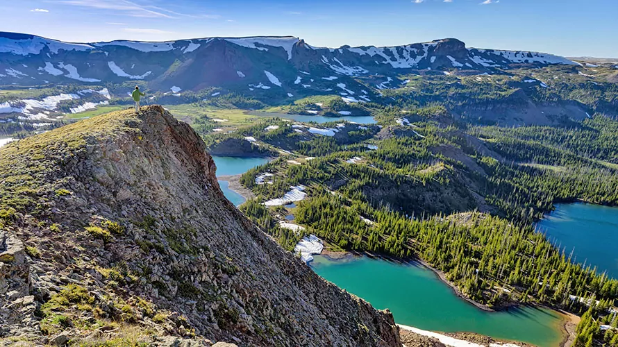
3. Flat Tops Wilderness Backpack
The Area
The Flat Tops Wilderness is largely attributed to inspiring the 1964 Wilderness Act. It occupies more than 235,000 acres in both the White River and Routt national forests. A haven for true backcountry exploration, thanks to its countless alpine lakes and expansive valleys, the Flat Tops is a backpacker’s paradise. Known for solitude and wildlife, this mountainous domain is defined by its unique, varied geography, and hard-to-Instagram beauty. Expect old-growth forest, mirror-clear lakes, and night skies straight out of a science fiction movie. This area was protected in 1975 and is due north of Glenwood Springs, CO.
Trip Overview
There are a number of routes to follow in the Flat Tops, but consider heading toward the 12,000+ Trappers Peak region from Trapper’s Lake and Shepherds Rim Campground, off of Route 8. Expect to experience a truly unique mountain environment in the Flat Tops, as the jagged authenticity of the Maroon Bells is replaced with sprawling high plateaus and lake-spotted valleys. Visit the Island Lakes district, defined by its far-reaching collection of alpine lakes and watersheds. The Wall Lake Trail will put into verdant valleys and creates an ideal set-up for a summit of Trappers. Overall, the trip gains and loses thousands of feet, explores lush creeksides, offers incredible backcountry fishing and wildlife viewing, and reveals a part of Colorado few people know is there.
Getting There
From Denver:
Head west on I-70 to the town of Wolcott, where you’ll pick up 131 North toward Yampa. Head west on the winding Route 8, then dip south on 8A/155 South/Trappers Lake Rd. to Trappers Lake. Shepherds Rim Campground sits on a loop near Crescent Lake.
From Glenwood Springs
The fastest route is to head west on I-70 to Rifle, then go north on CO-13 North toward Meeker. There, you’ll catch 8, heading east to Trapper’s Lake Rd. Head south until the road ends and the campground signage becomes evident.
Recommended Day by Day Itinerary
Day 1:
If starting in Denver, plan for a lengthy drive west, and consider a break for lunch at one of the many roadside opportunities western Colorado offers. Find a campground near Trappers Lake, get settled, and prepare for hitting the trail the next day. You’ll end the drive at just under 10,000 feet.
Day 2:
Time to get started. Leave from Trappers Outlet trailhead, journeying along the lake for a mile or so, then gain altitude out of the valley on Trappers Lake Trail. Once you’ve arrived at camp, settle down for the evening at over 11,000′ near the intersection with Island Lakes Trail (you’ll have gained 2,000 over 7 miles!) The views will not disappoint, and they show off the region’s incredible beauty.
Day 3:
Remain camped on this day, and spend your hours exploring the Island Lakes, a series of pocketed, snowmelt alpine lakes, streams, and rocky outcrops. Watch for wildlife exploring the area or try your luck fishing in one of the countless lakes (CO fishing licenses required.) After you’ve had your fill, head back to your tent for dinner and shuteye. You’ll gain and lose about 1,000 feet over 6.5 miles.
Day 4:
Take today to move camp and trek along the Wall Lake Trail through its giant meadows and near its crisp streams. It won’t take long to reach your camp on the shores of Wall Lake so settle in. Once rested, grab your essentials and attempt the summit of 12,002-foot Trappers Peak. You won’t want to come down, but you’ll need to avoid afternoon thunderstorms, sending you back to camp early. But what a day. This is about 5 miles and a loss/gain of 1,300′.
Day 5:
Staying north on the Wall Lake Trail, you’ll take in even more of what the Flat Tops are all about—big views, rich forests, and authentic Rocky Mountain environments. Heading back to the Trappers Lake trailhead will seem like that sad bus ride to school on the first day after the summer break—but boy, the pictures you’ll be able to share come “Show & Tell” day. It’s about 5 miles back to the trail, and a loss of 1,700′.
Permits and reservations
Private parties and individuals do not need permits to backpack in the Flat Tops Wilderness, but always view the National Forest website to confirm and learn of any closures.
When to hike
Mid- to late-summer and early fall are the ideal times to hike in the Flat Tops Wilderness. Be wary of heavy stream crossings and wetlands, and especially of summer thunderstorms if above treeline.
Campsites
Night 1: Shepherd’s Rim campground
Night 2: Established backcountry site near junction of Trappers Lake and Island Lakes trail
Night 3: Same as night 2
Night 4: Established site along shores of Wall Lake
Hike with a Guide
Guided Flat Tops Wilderness backpacking trips are available, and are a stress-free, exciting way to do this trip. The tour company handles permits, gear, transportation, meals, and provides a professional guide so you can focus 100% on enjoying your adventure. Read more…
As the world’s premier hiking and trekking company, Wildland believes in connecting people to fantastic environments in amazing ways. Grand Canyon National Park offers an array of incredible hiking and trekking experiences. Wildland Trekking provides 21 different multi-day hiking and backpacking adventures in the Canyon. Read more about our Colorado Hiking Trips.
To learn more about our guided backpacking trips and all of our award-winning hiking vacations, please visit our website or connect with one of our Adventure Consultants: 800-715-HIKE
